
That’s right, McWay Cove located in Julia Pfeiffer Burns State Park, is one of the most amazing beaches I have ever seen, but it's actually illegal to go onto the beach. That’s okay. It adds to the mysterious grandeur knowing it is forbidden. And there is a peacefulness knowing it will go unharmed by humans. As you can see, the view is accentuated by a rare coastal waterfall, making it one of the most photographed waterfalls in California.

Why hadn't we been here before? Well it is a bit out of the way. We just happened to be heading south on Highway One to Cambria last summer, and my hubby said we had to stop on our way to see some waterfalls.
 I thought, “If these waterfalls were worth seeing, we wouldn't we have done so in the past 18 years we have lived in this area?”
Boy, was I happily wrong!
Julia Pfeiffer Burns State Park is located 37 miles south of Carmel along Highway One. The parking lot is on the eastside of the highway, and the parking fee is $10. There are other hikes you can take from here, but to see the McWay Falls you take the signed trail toward the Overlook Trail. The path leads through a tunnel under the Highway.
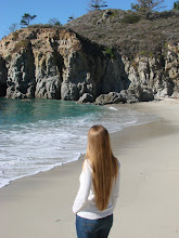
Veering to the right, the trail leads you to a gorgeous view of the Big Sur Coast.
As you are hiking you will come upon the first overlook of the McWay Falls, cascading 80 feet below into McWay Cove (this is where most people take photos of the Falls).
But my favorite vista of the falls was further down the trail, towards the former site of the Waterfall House. I loved the huge palm tree framing the view of the cove.
Just a short distance from the waterfall are the ruins of an old stone "waterfall house", owned by Lathrop and Helen Hooper Brown back in the 1940s. Not much is left of the house, but it is an interesting site. It is amazing to think that someone actually lived here, surrounded by such beauty. What a life! The park was named after Brown’s friend, Julia Pfeiffer Burns, who was a respected resident and rancher in the Big Sur region in the early 20th century.

This is where the trail ends, at the site of the old Waterfall House. The Big Sur Coastline to the north was again, breathtaking.

The easy hike to view the falls and to the site of the old Waterfall House was only about 10 minutes one way. Well worth the while! What a fun tasty treat on our way to Cambria, it was as though we had taken a sidetrip to a tropical island!
(Below: Video of the view from the Waterfall House and a peak at the McWay Falls--enjoy!)
 How to get across the Golden Gate Bridge? We had driven across numerous times, on our way to somewhere else, but this time we wanted to cross just for the sake of experiencing the bridge itself. We thought of walking across, but how would we get our 10 year old daughter to walk the 1.7 miles to one side, and turn around and walk all the way back? My husband suggested walking halfway across, and then back. That would never do. I could never boast to my friends, “I have walked half-way across the Golden Gate Bridge!” So we decided to park our SUV on the north side of the bridge, ride our bikes across the bridge, towards the city, and then back again.
  Sounds easy, right? But I didn’t realize that the bridge was really alive! That is right, the bridge bounces from the movement of traffic, it roars from the traffic crossing it, and it is laced with intimidating crosswinds off the ocean and oncoming traffic. I wasn’t psychologically prepared for the undertaking—but it was too late, I found out all of these things once we had already begun our journey!
  We had spent the entire day biking around Golden Gate Park, and decided to tackle this little jaunt towards the end of our day. Needless to say, we started riding our bikes on the east side of the bridge, heading south towards the city, during evening rush hour.


 Hmmm, moving right along . . . here are some interesting facts I found out about the bridge. It took 4 years and cost more than 35 million dollars to build. Upon completion in 1937, the Golden Gates’ 4200 feet long main span was the longest suspension bridge span in the world. The weight of its road is hung from two cables that pass through two main towers located towards each end of the bridge. There are 80,000 miles of wire in the main cables.
  The paint color of the bridge is officially called International Orange, chosen to compliment the surrounding area and make the bridge stand out in the fog. The two towers rise 500 feet above the roadway.
  There are 5 traffic lanes; yellow markers are moved to adjust to the traffic flow.


 I was relieved to find out when we were riding back, going with the flow of traffic, there were no more crosswinds to contend with. Whew!
  After we had completed our ride, I felt a big sense of accomplishment. What a rush—a real “high” from life. Even my daughter was amazed at the feeling she was left with after crossing that red sleeping giant.


